Skip to content
William Penwell

The record

A county at the top of Michigan

Sisu Bay is not on the map. Everything around it is.

The county is Keweenaw, at the top of Michigan's Upper Peninsula — a finger of rock running north-east into Lake Superior, with the lake on every side but one. What follows is that county's actual history, because the novels are built on it and because it is a better story than most invented ones. The bay is the single thing in here that does not exist.

About 1.1 billion years ago

The continent tried to come apart

Everything up here starts with a failure. Roughly 1.1 billion years ago the middle of what is now North America began to split, the way Africa is splitting today. A rift opened, and for some millions of years lava came up through it in flow after flow, thousands of feet of basalt piling into a subsiding basin. Between eruptions, rivers swept gravel across the top of the cooled rock and left beds of conglomerate.

Then it stopped. The continent did not finish tearing, the basin sagged under its own weight, and the whole stack was folded and shoved upward along faults on either side. What is left of it is a broken trough. The Keweenaw Peninsula is one lip of that trough. Isle Royale, forty-odd miles out in the lake, is the other.

You are looking at the same rocks in both places, tilted toward each other across the water. The lake sits in the middle because the middle is where the ground gave way.
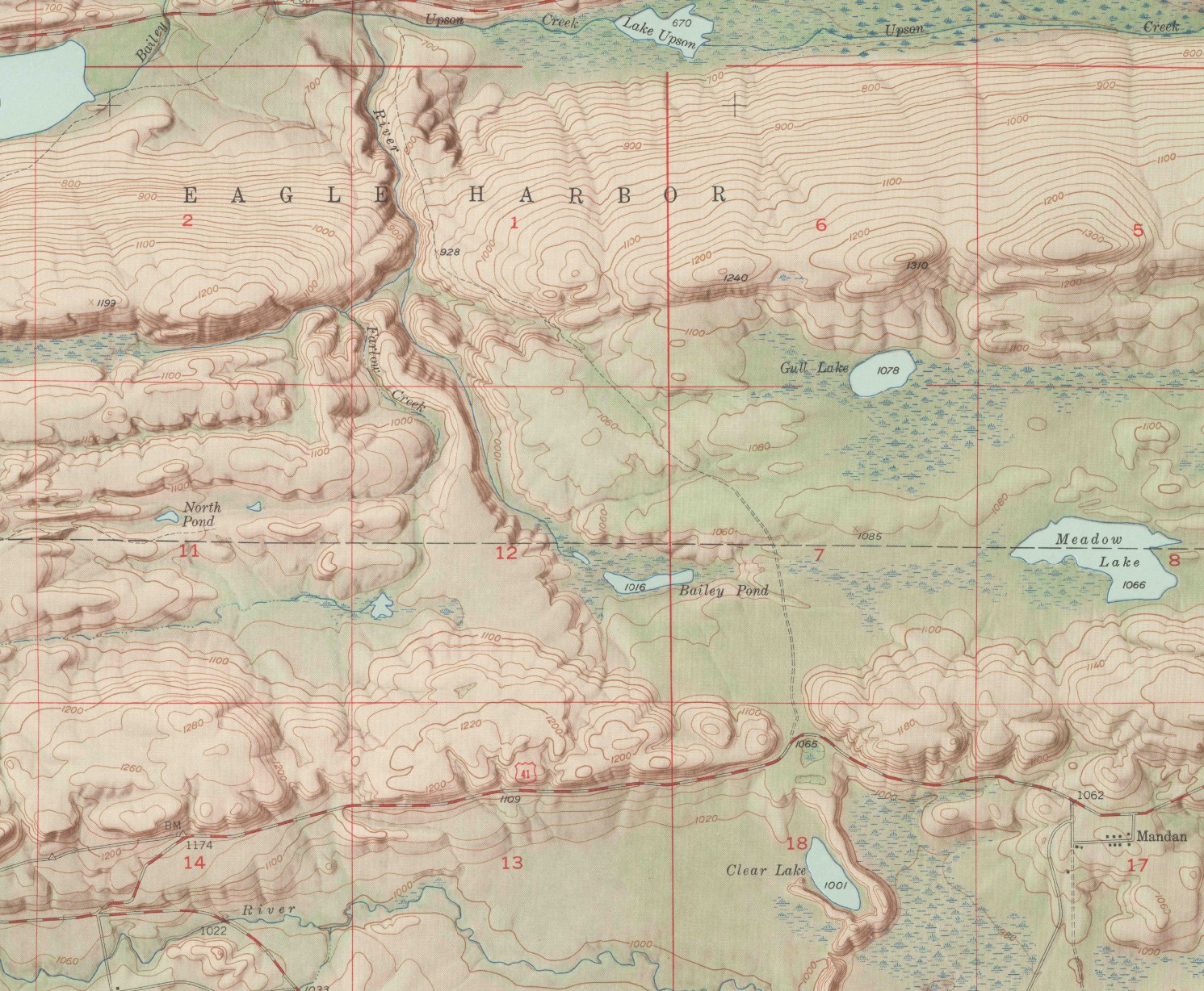
Detail of the 1948 United States Geological Survey topographic map of the Delaware quadrangle, Keweenaw County, Michigan, shaded to show a long ridge running from lower left to upper right, with the red section grid of the public land survey over it.

The rift is not a thing you can be shown directly; it is eleven hundred million years old and most of it is under the lake. What you can be shown is the shape it left, and this sheet is the clearest picture of that shape I have found. The ridge runs south-west to north-east across the whole quadrangle in parallel bands, one tilted flow after another, because that is how the rock was laid down and how it was afterwards shoved up on edge. Everything else on the sheet obeys it: the creeks run in the troughs between the bands, the lakes sit where the troughs pond, and the highway follows the low ground because there is nowhere else for it to go. The red grid over the top is the public land survey, laid out in squares by men who did not care what was underneath. EAGLE HARBOR across the middle is the township, not the village.

The whole Delaware quadrangle

Delaware Quadrangle, Michigan. U.S. Department of the Interior, Geological Survey, 1948. Historical Topographic Map Collection. Public domain.
Native copper

Metal you can pick up

Copper almost everywhere on Earth is an ore — the metal is chemically bound up in rock and has to be smelted out of it. On the Keweenaw it is not. Superheated water moving through the rift's fractured basalt deposited copper as copper: pure, metallic, sitting in the gas cavities of the old lava flows and in the spaces between the pebbles of the conglomerate.

It comes in sheets, in wires, in lumps, and occasionally in masses weighing hundreds of tons that had to be cut apart underground before they could be lifted out. Glaciers dragged some of it away and dropped it as float copper, so pieces of the deposit turn up in fields far to the south of where it formed.

This is close to unique, and it is the whole reason for the county. A place where you can find metal lying in rock is a place people will come to from a very long way away.

Thousands of years

The oldest workings are not the companies'

The nineteenth-century miners were not the first. Copper was worked on this peninsula and on Isle Royale for thousands of years before them — shallow pits, hammerstones, fire and water used to break rock, and the metal cold-worked into tools and ornaments that were traded across a great deal of the continent. It is among the oldest metalworking anywhere in the world.

The Anishinaabe were and are the people of this country. In 1842, by the Treaty of La Pointe, the Ojibwe ceded the western Upper Peninsula to the United States, and the mineral district was opened to entry the following year. That treaty is the reason there was a rush at all. The Keweenaw Bay Indian Community is here today, south of the peninsula on Keweenaw Bay.

This is stated because it is what happened. It is not the subject of these novels, and nothing invented in them draws on it.

1841–1845

The first mineral rush in the country

Douglass Houghton, Michigan's first state geologist, reported on the copper in 1841 in terms he intended to be sober. He warned explicitly against speculation. The report had precisely the opposite effect, which is the usual fate of a sober report about metal.

By 1843 the rush was on — five years before California, and the first mineral rush in the country's history. Men came north with leases from the War Department and dug into hillsides on evidence that ranged from a geologist's map to a rumour. Most of it failed. A great many companies were floated, capitalised, worked for a season and abandoned, and the paper they left behind is a large part of what makes a chain of title up here so long.

Houghton himself drowned in the lake off Eagle River in 1845, at thirty-six, which the county has never entirely got over.

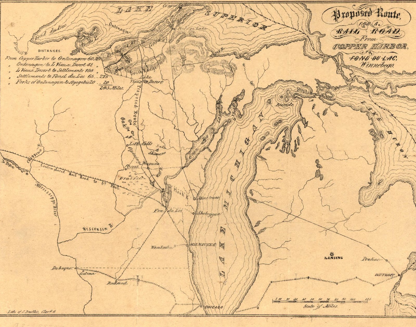
An 1853 lithographed map of the Lake Superior copper region showing a proposed railroad route from Copper Harbor to Fond du Lac, with distances tabulated at the upper left.

This is what the rush looked like from inside it. A meeting at Ontonagon in November 1853 resolved to ask Congress for land to build a railroad from Lake Winnebago to the copper mines, and had this map lithographed above the printed report to make the case. The distance table at the top left runs Copper Harbor to Ontonagon, sixty miles; the whole line, two hundred and ninety-three. The railroad was not built on this route. The Library of Congress accessioned the sheet in August 1906 and its stamp is still on it.

The whole sheet, map and printed report

Proposed route for a rail road from Copper Harbor to Fond du Lac. Cleveland, 1853. Library of Congress, Geography and Map Division.

1845 onward

The Cliff, and what a fissure is

The first mine to return real money was the Cliff, at the base of the greenstone bluff behind Eagle River. It worked a fissure — a vertical crack in the basalt filled with copper, sometimes in masses so large the problem was not finding the metal but getting it out.

Fissure mines were spectacular and short. They made fortunes and then they ran out, because a crack has a bottom. The Cliff paid dividends for two decades, drew a village around it, and is now a name on a map with almost nothing standing.

What replaced it was duller and vastly bigger.

1864–1871

The conglomerate, and the company that ran everything

In the mid-1860s prospecting on the ridge above what became Calumet found copper not in a fissure but distributed through an entire bed of conglomerate — an old river gravel, cemented and tilted, with metal in the spaces between its pebbles. It was poorer rock per ton than a fissure and it went on for miles.

That is a different business. It requires shafts, hoists, rock houses, stamp mills, railroads, a smelter, and thousands of men on shift. Calumet and Hecla consolidated in 1871 and for a generation ran the richest copper operation in the world, paying dividends that made Boston investors rich and building a company town with a library, a bathhouse and a theatre in it.

It also owned the houses. That fact sits underneath everything that happened later.

1860s–1910s

Who came, and what they brought

Cornishmen came first in numbers, because Cornwall's own mines were failing and Cornish hard-rock skill was the most valuable thing in the industry. They brought the pasty, which is now the food of the region regardless of anyone's ancestry, and a great deal of underground vocabulary.

Then Finns, who became the largest group and left the deepest mark: sauna, cooperative stores, a temperance and labour tradition, and the word sisu — a kind of persistence that does not announce itself and is not the same as courage. Then Italians, many of them from the south, and Croatians, Slovenians, Swedes, Norwegians, French Canadians, Irish, Germans, Poles.

By 1910 this was one of the most polyglot places in America, sixty miles from anywhere, with newspapers in half a dozen languages and church suppers that did not overlap. The county's surnames are still the record of it.

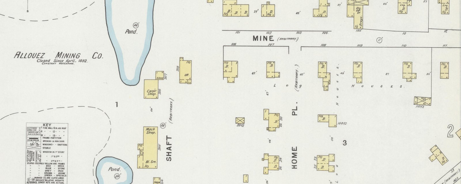
Detail of the May 1895 Sanborn fire insurance map of Allouez, Michigan, showing the Allouez Mining Company works on the left and blocks of company dwellings on the right, with the words LOG HOUSES lettered across them.

A fire insurance surveyor walked this village in May 1895 and drew every building in it, because an underwriter needed to know what would burn. That is why it is the best picture we have of how these people actually lived. On the right are the blocks people lived in — Mine Street and Home Place — where every small yellow rectangle is a frame building, most of them marked D. for dwelling with the number of storeys written on them, and the surveyor has lettered LOG HOUSES straight across the whole block, because that is what most of them were. The title block records a population of a thousand, no steam engine and no hand engine, no independent hose carts, no fire department, water facilities none, and prevailing winds west — the last of which is on there because a village of log houses with no water burns downwind. On the left is the mine that the whole village was there for, and beside it the surveyor's own note: closed since April 1892, constant watchman.

The whole Sanborn sheet

Sanborn Fire Insurance Map from Allouez, Keweenaw and Houghton Counties, Michigan. Sanborn Map Company, May 1895. Library of Congress, Geography and Map Division, Sanborn Maps Collection.

The shore

How the beaches turned grey

Rock came out of the ground with a few pounds of copper in a ton of it. Getting the metal out meant crushing the rock to sand under steam-driven stamps and washing it, and that produced enormous quantities of waste — stamp sand, or poor rock, depending on who you asked.

It went into the water. For decades the mills put their tailings straight into Torch Lake and into Lake Superior on the theory that the water was big enough, and the water has been handing it back ever since. At Gay, on the eastern shore, the stamp sand from a mill that shut in the 1930s is still migrating along the coast and is still the subject of active engineering.

The result is a shoreline in places that is not sand at all. It is grey-black, sharp underfoot, tens of feet deep, and almost nothing grows in it. It is the county's own industrial history, physically returned to the beach and declining to leave.

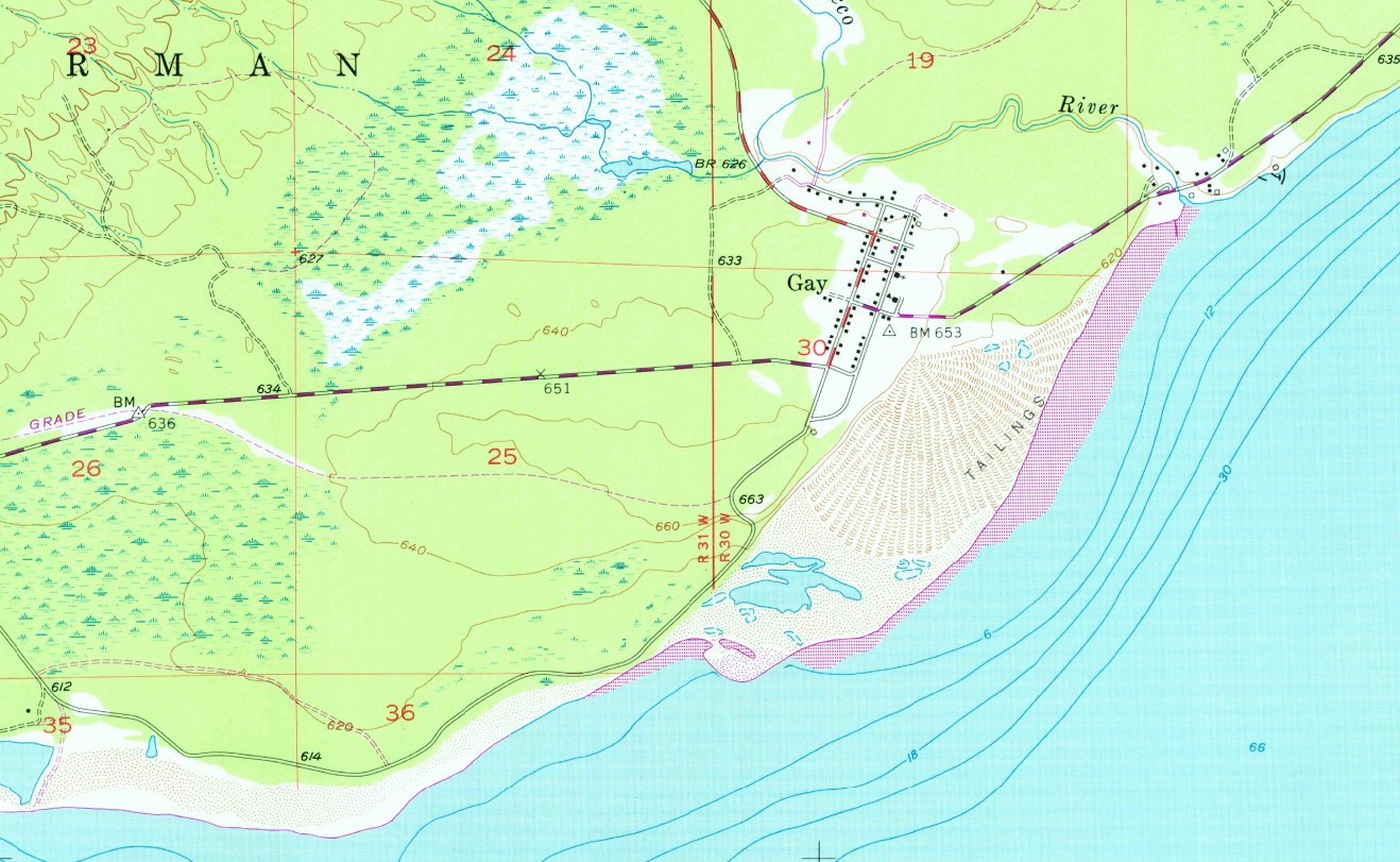
Detail of the 1954 United States Geological Survey topographic map of the Gay quadrangle, Michigan, showing the village of Gay and a large fan of stamp sand lettered TAILINGS extending along the shore of Lake Superior.

The Geological Survey put it on the map as a landform. Gay is the little grid of black squares at the top; the pale fan below it, ridged and stippled and lettered TAILINGS, is what came out of its mill. It is drawn the way a delta or a dune field is drawn, because by 1954 that is what it had become — and it is plainly larger than the village that made it. The mill had already been shut for about twenty years when this sheet was surveyed. The small blue shapes caught inside the fan are ponds that formed in the sand.

The whole Gay quadrangle

Gay Quadrangle, Michigan. U.S. Department of the Interior, Geological Survey, 1954. Historical Topographic Map Collection. Public domain.
1913–1914

Nine months

In July 1913 the Western Federation of Miners struck across the Copper Country over hours, pay, and the one-man drill that had replaced two men with one. It lasted about nine months. The companies imported deputies, the National Guard came in, and the district turned into something close to an occupied place.

The strike was broken. Many of the strikers left the peninsula for good, and the industry never recovered either its labour force or its confidence. What had been the richest copper district in the world spent the next fifty years managing a decline.

1920s–1968

The pumps stop

The problem underground was never running out of copper. It was that the copper got poorer as the shafts got deeper, and the deeper you go the more water you fight. A mine is a hole that fills; the only thing keeping it open is pumping, and pumping costs money that a low-grade ton does not repay.

The wars bought time. After them the arithmetic reasserted itself, and the operations closed one by one. Calumet and Hecla's ended in 1968 after a strike, and when the pumps stopped, the workings began to flood — which is what they have been doing quietly ever since, mile after mile of them, under a county with two thousand people in it.

There is a great deal of engineered space under the Keweenaw that no one has stood in for sixty years.

The county now

What is there

About two thousand people, which makes Keweenaw one of the least populous counties in Michigan and the least dense by a distance. Forty-odd miles of road up the spine, US-41 running out at Copper Harbor, M-26 along the north shore through Eagle River and Eagle Harbor. Snow from November to April and sometimes past it.

The mines are the National Historical Park now, and the ruins are stabilised rather than restored. The rock houses stand where the shafts were. The stamp sands are still on the beaches. People live here on tourism, timber, the park, and on not especially wanting to be somewhere else.

It is a place that had the world's attention for about fifty years and has had none of it for a hundred, and has arranged itself accordingly.

The one invented thing

And Sisu Bay

Everything above is real and can be checked. Sisu Bay cannot.

In these novels there is a bay near the far end of the peninsula that the county uses in every instrument it records and the federal government has never once printed. It is not on the quadrangle. It is not in the gazetteer. The Postal Service calls the place Eagle Harbor. Everybody who lives there calls it Sisu Bay, and has since before anybody can produce a document for.

That is the whole series in one line — the paper says one thing and the ground says another — and it is the kind of discrepancy a title examiner is paid to resolve and, in this case, cannot. There are three stories about where the name came from. Nobody in the county will choose between them.

The rest of the county is exactly as described above, which is the point. A place this strange does not need much help.

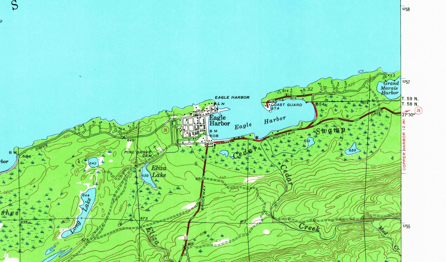
Detail of the 1946 United States Geological Survey topographic map of the Eagle Harbor quadrangle, Keweenaw County, Michigan, showing the village and the harbour on the north shore.

This is the quad sheet. The Geological Survey mapped it in 1946 at 1:24,000, with a twenty-foot contour interval, and it names everything: the village, the harbour, the Coast Guard station, Pine Grove Cemetery, Eliza Lake, Long Lake, Brockway Drive, and Grand Marais Harbor to the east. Copper Harbor is twelve miles on. Every name the county uses is here except one, and the water in the middle of this picture is labelled Eagle Harbor.

The whole Eagle Harbor quadrangle

Eagle Harbor Quadrangle, Michigan. U.S. Department of the Interior, Geological Survey, 1946. Historical Topographic Map Collection. Public domain.
Everything on this page about Keweenaw County is real history and can be checked against the published record. Sisu Bay is invented, and so is everything that happens in it. Where a figure is commonly cited rather than something I could verify to a primary source, it is written as what is recorded or posted rather than asserted.

There is more of this

The documents go out by email

This page is the standing part. The rest is the paper — a plat, a chain of title, a school register, a page from a book somebody kept for a very long time — and it goes to the list, with the research behind whichever book I am writing. Nothing sent there appears in any of the novels.

Or start with the books